Walking tours are a perfect way to get outside and explore your community — especially during the fall season when it’s not too hot or cold. We’ve previously shared several walking tours, including a historical walking tour of the Journal Square neighborhood, a Frank Sinatra walking tour, and now, we invite you to take a walk back in time and follow along with our curated, self-guided, historical walking tour of Jersey City Heights.
Getting There
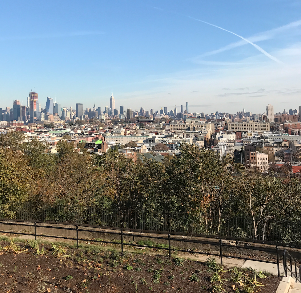
The Heights is situated atop the banks of the Palisades along the west side of the Hudson River, above Hoboken. The area is settled between Paterson Plank Road on the north side, Highway 139 on the south side, Hoboken on the east side, and the Hackensack River on the west side. Getting to The Heights from downtown Jersey City requires some planning, but it’s quite easy to access from Hoboken.
From Hoboken, right outside the 9th Street/Congress Street Light Rail station, there is an easy-to-find elevator that will take you up to The Heights. There are also steps (See Stop #10!) near the 2nd Street Light Rail station that you can take up to The Heights neighborhood.
From downtown Jersey City, you can get to the Heights by taking the Hudson-Bergen Light Rail to the 9th Street/Congress Street station, biking, taking an Uber, or driving if that’s an option for you.


From NYC, you can take Bus 119 from Port Authority to get to the neighborhood.
Read More: The Sinatra Walking Tour: Hoboken With Ol’ Blue Eyes Himself

The History of the Name
The Jersey City Heights neighborhood wasn’t always known as “The Heights.” In 1852, the land which we recognize today as The Heights was incorporated as a town called Hudson City. It wasn’t until 1870 that Hudson City merged with the city of Jersey City and later, gained its nickname.
According to jcheights.com, The Heights sits 100 feet above sea level. The area we recognize as The Heights today is much smaller than what The Heights was known as years ago. Before Jersey City acquired Hudson City, the nickname referred to the string of towns atop the Palisades on the banks of the Hudson River.
Stop #1: Washington Park
View this post on Instagram
Location: Paterson Plank Road and North Street
Washington Park is easy to access upon making your way up to The Heights from 9th Street. Walk up Palisade Avenue until you see the park.
Washington Park is unique in that it is the only park in Hudson County that services and sits between two municipalities — Jersey City and Union City. The park is 22 acres, run by Hudson County, and sits atop the New Jersey Palisades on the north border of Jersey City.
The park was built on land that was owned by a wealthy New York family, the Stuckleys, in the 1800s. Until the 1900s, the principal purpose of the park was to serve as a carnival ground. The Stuckley family held fairs, circuses, and Wild West shows so frequently that back then, the park was recognized as a carnival or campground more so than a park.
In the 1930s, the park was purchased and redesigned through the Works Progress Administration Act, passed in 1935, which carried out public works projects while simultaneously stimulating job growth throughout America. Today, the park offers space for recreational sports like baseball, tennis, basketball, soccer, and racquetball. There is a children’s playground, picnic area, and gazebos to enjoy, as well.
You can walk through the park and make your way to Central Avenue, the next stop.
Stop #2: Central Avenue
View this post on Instagram
Location: Central Avenue/CR 633
Central Avenue is a Hudson County road that spans 12 blocks long and ¾ of a mile straight through The Heights. Central Avenue has one four-way intersection in the shopping district at Hutton Street, but otherwise, most interactions down the street’s path are T-intersections. Central Avenue was the main street for the city previously known to occupy The Heights between 1860-1870 — Hudson City. It wasn’t until the 1900s that Central Avenue began taking its shape as a commercial street in the neighborhood. Since then, Central Avenue’s storefronts have changed over the years to reflect the transformation and growth of the neighborhood. Today, it’s lined with residences, restaurants, and shops like Dulce de Leche Bakery, Saigon Bistro, and more.
Stop #3: Leonard J. Gordon Park aka Mosquito Park
Location: Kennedy Boulevard between Manhattan Avenue and Hutton Street, West to Liberty Avenue
Walk down Central Avenue until you see a park in sight. This park, Pershing Field Memorial Park, is Stop #5. Turn right at this park onto Manhattan Avenue until you make your way to Leonard J. Gordon Park, which happens to be rich with history.
The land where the park stands today was sold to Jersey City from a private charter company for $46,000 in 1907. The park underwent a redesign shortly thereafter, which included the introduction of the large Buffalo and Bears (c. 1907) statues to the park, which were crafted by sculptor Solon Hannibal Borglum. Borglum may not be very well known, but his brother, Gutzon, is the sculptor behind the famed Mount Rushmore, as well as a statue of Abraham Lincoln in front of the Essex County Court House in Newark. Another unique statue in the park is the World War I memorial Dough Boy, placed on November 9th, 1930 by the Hudson City Soldiers and Sailors Welfare League.
The park was named after Dr. Leonard J. Gordon, who city leaders agreed should be recognized for his legacy to the city of Jersey City. Dr. Gordon was a NY native and served in the Union Army during the Civil War. He moved to Jersey City and got his medical degree from Bellevue Medical Center in 1875, completing an internship at the Jersey City Charity Hospital, which is now known as Jersey City Medical Center.
Dr. Gordon contributed to JC in a few ways, according to historical findings. First, he advanced the placement of the sculpture Soldiers and Sailors Memorial by Philip Martiny in front of City Hall. Second, he advocated strongly for the opening of the Jersey City Free Public Library. Additionally, he took on the role of president of the library’s board of trustees and then the library’s director. The library on Jersey Avenue in downtown Jersey City has a bust and memorial window in Dr. Gordon’s honor, which was donated by residents in February 1907.
Yes, Leonard J. Gordon Park’s nickname “Mosquito Park” does, in fact, derive from the famous insect. Rumor, according to JCList.com, has it, that the park was much more marshy in the 1900s and attracted the pesky bugs, earning itself the nickname. Rest assured, the park is not known today for being infested by mosquitos.
Stop #4: White Mana Diner
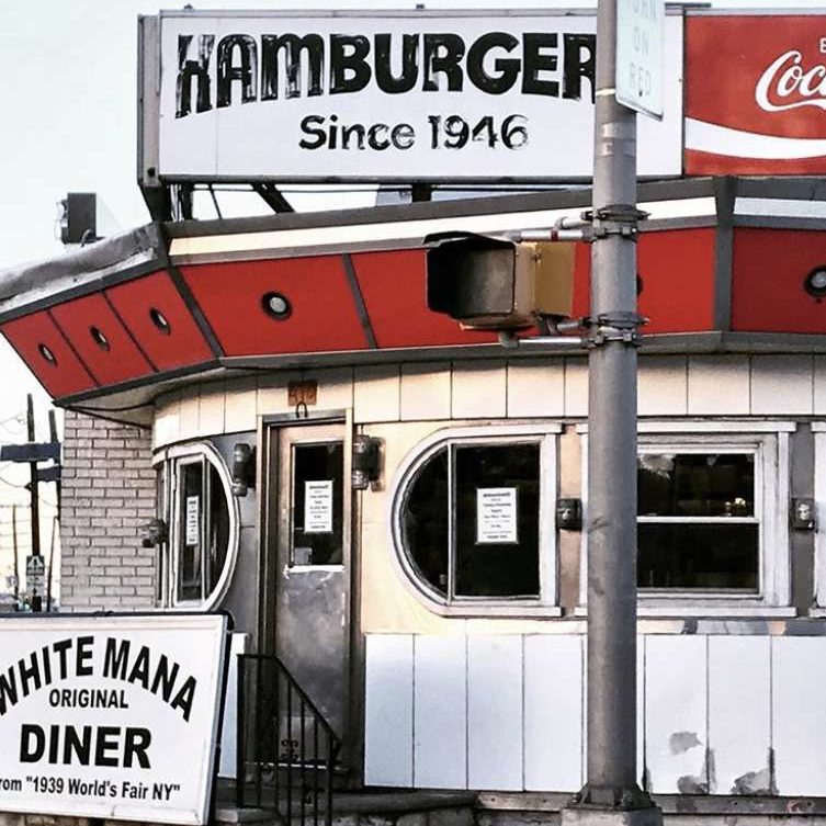
Location: 470 Tonnele Avenue
One block from the park down Manhattan Avenue, you’ll find this gastronomical landmark.
In 1939 at the World’s Fair in Flushing Meadows, Queens, a diner specializing in burgers introduced itself to the world claiming it was the “diner of the future,” according to NY Eater. Years later in 1946, a distinct, circular, futuristic-looking building was built by Paramount Diners of Oakland, NJ, and White Mana was introduced to Jersey City. There is a White Manna location in Hackensack that you may have noticed has an extra “n” in its manna. Rumor has it the location in Jersey City lost an “n” thanks to a painter’s mistake when it originally opened.
Today, White Mana has the same menu and fresh-never-frozen mentality it did in 1946. The White Mana burgers are not quite like White Castle or at all like Five Guys. The burgers are small, only $1.12 each, and come standard with onions, dill pickle chips, and ketchup. Spoiler alert: this diner also serves disco fries. Needless to say, there’s a reason this place has been around for 80 years.
Stop #5: Pershing Field + Reservoir #3

Location: 210 Central Avenue + 119-199 Reservoir Avenue
Follow Manhattan Avenue back up the path you came and make your way to Pershing Field Park.
Pershing Field Park opened in 1922 and was dedicated a year later to commemorate and honor soldiers lost during World War I who had called Jersey City home. Today, Pershing Field has many more memorials dedicated to members of the armed forces who lost their lives in subsequent military activity. Pershing Field Memorial Park is roughly 13.5 acres and one of the largest of Jersey City’s parks, in which there are plenty (40+). The park’s name honors World War I hero, General John J. Pershing.
As you enter the park from Summit Avenue, you will see a large arch of red sandstone, which are the remains of an armory that previously stood at Montgomery Street and Bergen Avenue. The armory was destroyed in 1927, but the arch was salvaged and rebuilt in 1941 at Pershing Field. It was later named a Jersey City historical site.
You’ll easily find an eight-foot tall bronze memorial statue known as America Triumphant by James Novelli, which was placed in the park on its opening day, July 4th, 1922. It was decided the land, which was previously used as a military training ground for World War I, would become a park as the growing population post-war needed community space for recreation and leisure.
As you walk through the park towards Central Avenue, you will see track fields, tennis courts, a baseball field, and facilities that house a swimming pool and skating rink. There is also a children’s playground at Pershing Field.
Reservoir #3, which sits right next to Pershing Field Memorial Park, predates the park. It was erected between 1871 – 1880 and recently re-opened after years-long renovations. The Reservoir used to be 1 of 3 main water supply sources to Jersey City but has been long abandoned. Now, it’s a nature and wildlife sanctuary.
Stop #6: Pohlmann’s Hall
Location: 154 Ogden Avenue
Walk north up Palisade Avenue about eight blocks and make a right on Ferry Street, which will bring you to face 154 Ogden Avenue.
Pohlmann’s Hall was built in 1874 by Diedrich Pohlmann, a German immigrant through Ellis Island, and used primarily as an athletic club. Over time, the hall became a sort of welcome center to fellow German immigrants, a hotel, theater, meeting, and event space for the community through the late 19th century. Pohlmann’s Hall was purchased by a boiler company that used the building for its corporate headquarters in 1918. It changed hands a few times after that until 1984 when the present owners bought the building and transformed it into condominiums. The building was added to the National Register of Historic Places on September 5th, 1985.
Walk north up Ogden Avenue and you’ll make your way to Stop #7.
Stop #7: Riverview Fisk Park
Location: 498 Palisade Avenue
Riverview Fisk Park was designed by prominent landscape artists John T. Withers and Addison T. Hastings. Withers also designed Leonard J. Gordon Park. There is a bust statue of a man with a large, Shakespearean collar who is often mistaken for Shakespeare himself. This man is none other than Henry Hudson, the namesake of Hudson City and a local history hero. The bust was dedicated in 1917. The park is home to many community activities including a farmer’s market and a jazz festival. The park’s recent renovations were completed in Spring 2021. The renovations included updating the bocce field, installing a spray pad, and planting over 80 trees.
Continue walking north up Palisade Avenue and on the left side of the street, you’ll see Stop #8.
Stop #8: The Van Vorst House
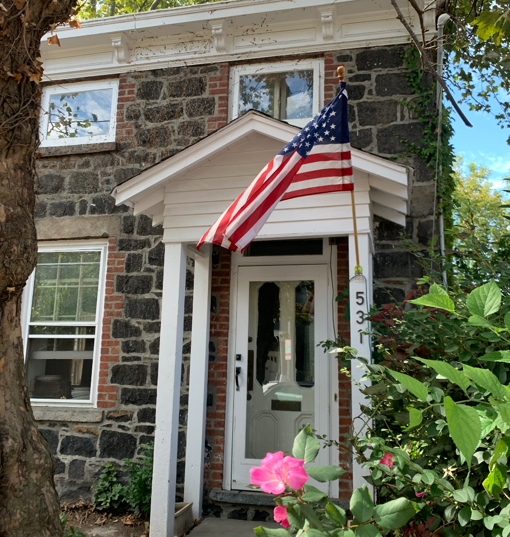
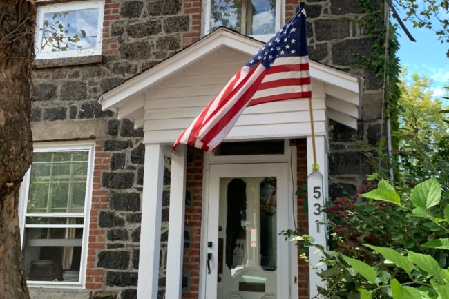
Location: 531 Palisade Avenue
The Van Vorst House is arguably the oldest building in Jersey City, said to have been built between 1740-1742. The stone house was first home to the prominent Van Vorst family, who settled on this side of the Hudson River in 1647. The descendants of the Van Vorst family were integral in the development of Jersey City and are connected to many other local pieces of history including the Barrow Mansion and Van Vorst Park.
Stop #9: 100 Steps

Location: Mountain Road
Depending on how you plan to end this tour, you can make your way south down Palisade Avenue towards Mountain Road to Stop #10, or retreat north on Palisade Avenue to Congress Street.
The steps that connect The Heights with Paterson Plank Road, near the 2nd Street Hoboken Light Rail station, were built in the 1890s. The original steps were so disintegrated and dangerous, they were torn down in 1993. In 2013, the 100 Steps were re-constructed for $1 million.
In 2015, the steps were renamed “Bill Gaughan Way” to honor the longest-serving councilman in the history of Jersey City.
See More: Time Travel to Early Essex County at Morgan’s Farm + Museum in Cedar Grove
The Heights Today
Hanging out in The Heights today is always a fun time — with Central Avenue bustling with 200+ new and old small businesses, from restaurants to boutiques to specialty shops and more. Some of our favorite places to visit in The Heights include Alessio’s, The Alps, Bread + Salt, Busy Bee Organics, Corto, The Hutton, Dulce De Leche Bakery, Modcup Coffee, Lil’ Dove Cafe, Lucky HoneyBee, and Sure Things.
For a full guide on The Heights today, check out our article, Exploring Jersey City: Jersey City Heights.